Skip to content
FREE SHIPPING FOR ORDERS ABOVE $200
Skip to product information
1 of 2

Switzerland Pictorial Map Poster (1936) - Vintage Swiss Travel Wall Art

164,00 zł
164,00 zł 201,00 zł
Sale Sold out

Lowest price in 30 days: 164,00 PLN

Frame style: Unframed
Size: 91x61cm | 24x36in
  • Free Shipping - On All Orders Over $250!
Secure Payment
  • American Express
  • Apple Pay
  • Bancontact
  • BLIK
  • Google Pay
  • Maestro
  • Mastercard
  • Shop Pay
  • Union Pay
  • Visa

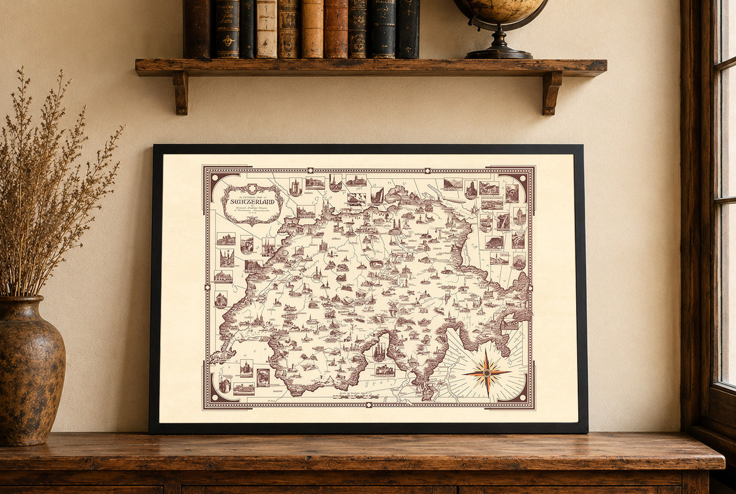
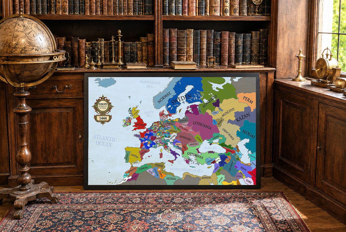
Discover the charm of vintage cartography with “A Pictorial Map of Switzerland,” a beautifully illustrated map poster created by Ernest Dudley Chase in 1936. Published in Winchester, Massachusetts, this decorative historical map captures the beauty, culture, and geography of Switzerland in a richly detailed pictorial style characteristic of early 20th-century travel and souvenir maps.

Rendered in elegant sepia tones, the map features hand-drawn illustrations of Swiss cities, towns, mountains, lakes, and famous landmarks. Pictorial relief techniques give the Alpine landscape a striking three-dimensional appearance, while decorative vignettes surrounding the border highlight important cultural and historical sites throughout Switzerland. A colorful compass rose and ornate title cartouche enhance the artistic quality of the composition, making it both informative and visually captivating.

This vintage Switzerland map poster blends geographic detail with artistic storytelling, offering a unique perspective on one of Europe’s most iconic destinations. Perfect for travel lovers, history enthusiasts, collectors, and admirers of antique maps, it adds timeless character and sophistication to any interior.

Ideal for living rooms, offices, libraries, studies, or mountain-inspired decor, this reproduction print celebrates the landscapes and heritage of Switzerland through classic pictorial cartography.

This is a reproduction print of a historical map

Author:
Chase, Ernest Dudley, 1878-1966

Date:
1936

Source: David Rumsey Map Collection, David Rumsey Map Center, Stanford Libraries

We use a top quality Canon printer
Canon ImagePROGRAF PRO 2600 providing:

  • 2400 x 1200 dpi
  • 12-color printing system using Lucia-PRO II inks
  • High-precision printing with 5 pl droplet size per color
  • Print head with nozzle compensation function

The print is done on Cotton Canvas (
390 g/m²) prociding a vintage map feeling.

Currently we offer black hardboard frames with polystyrene plastic front protection.

Available in sizes:

  • 91x61cm | 24x36in
  • 70x50cm | 28x20in

We work with a range of trusted logistics providers to ensure you get the best balance of cost and delivery quality, including FedEx, UPS, and DPD. We currently ship to 30 countries worldwide, including 25 countries within the European Union, as well as the United Kingdom, Switzerland, Canada, Japan and the United States.

All orders include full tracking, so you can monitor your shipment every step of the way. We also offer free shipping on all orders with a cart value above $200.

If your postal code is not supported by our standard shipping options, please contact us at contact@strategymaps.co
and we will arrange a custom shipping solution tailored to your location.

We have a 30-day return policy, which means you have 30 days after receiving your item to request a return. To be eligible for a return, your item must be in the same condition that you received it, and in its original packaging. You’ll also need the receipt or proof of purchase.

When buying within the European Union have the right to cancel or return your order within 14 days, for any reason and without a justification.

Read more about return policy here.

View Product Details

From map lovers for map lovers

Get Your Hometown Blueprint Map - Modern City Street Wall Art